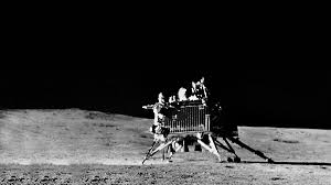
Indian scientists have made a groundbreaking achievement by creating the first comprehensive geological map of the Moon’s south pole, utilizing data from the Chandrayaan-3 mission. This new map offers critical insights into the lunar surface, providing valuable information about the region’s topography, crater formations, and geological history. The research, a collaborative effort between the Physical Research Laboratory in Ahmedabad, Panjab University in Chandigarh, and ISRO’s Laboratory for Electro-Optics Systems, represents a significant advancement in our understanding of the Moon’s evolution.
What Does the New Geological Map Reveal?
The map illustrates the diverse landscape surrounding the Chandrayaan-3 landing site, featuring both highlands and lowland plains. Researchers estimate that this area is about 3.7 billion years old, which coincides with the time when early microbial life was beginning to develop on Earth. This finding enriches our understanding of planetary science, enabling scientists to draw comparisons between Earth’s ancient geological activities and those of the Moon.
Furthermore, scientists have analyzed the arrangement of secondary craters in the area, confirming that debris from the Schomberger crater has significantly influenced the surface around Chandrayaan-3. By studying these crater patterns, researchers can better understand past lunar impacts, enhancing our models of the Moon’s geological history.
How Does This Map Help in Lunar Science?
Lunar craters are natural records of the Moon’s history, helping scientists figure out the ages of geological formations. By studying how craters are distributed and the composition of the surface, researchers can learn about the evolution of the Moon and other celestial bodies in the inner solar system over billions of years. The new geological map enhances our understanding of the Moon’s impact history, revealing the processes that have shaped its surface.
Moreover, this map provides critical information for future lunar missions. As space agencies, including NASA and ISRO, plan for Moon exploration and possible human settlements, detailed mapping of the south pole will assist in selecting safe landing sites and potential resource locations. The south pole is particularly significant due to the presence of shadowed craters that may contain frozen water—an essential element for future lunar missions.


