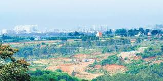
Odisha Chief Minister Naveen Patnaik has launched BLUIS-Bhubaneswar Land Use Intelligence System. The system will help in preventing encroachments of government lands with the help of satellites.
Daily Current Affairs Quiz 2020
Key-Points
Bhubaneswar Land Use Intelligence System is a geo-tagged repository of all the government lands in Bhubaneswar.
The new technology is introduced because the present mechanism of detection and enforcement lacks adequate transparency and accountability.
It is created through high-resolution satellite imagery to detect all changes taking place on government lands.
BLUIS is a web and mobile-based solution that will raise alarm over attempts to change the land use.
BLUIS will monitor changes in all government lands in Bhubaneswar by leveraging high-resolution satellite imagery.
This mobile application will alert the enforcement authorities of any new construction on government lands. The GPS on the application will guide the enforcement staff to the exact location and the evidence of enforcement will be uploaded on the application as geo-tagged images and videos.