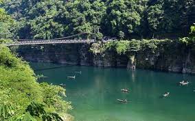
Stiff resistance from at least 12 villages in Meghalaya has cast a cloud on a 210 MW hydroelectric project on Umngot, considered India’s clearest river.
Daily Current Affairs Quiz 2021
The villages are near the border with Bangladesh in East Khasi Hills district but the dam is proposed upstream in the adjoining West Jaintia Hills district.
The project is to be executed by the Meghalaya Energy Corporation Limited. People of 13 villages along the Umngot are likely to lose 296 hectares of land due to submergence if the dam comes up.
Umngot flows through Dawki, a town in West Jaintia Hills district, Meghalaya. The river is the natural boundary between Ri Pnar (of Jaintia Hills) with Hima Khyrim (of Khasi Hills). Dawki Bridge, is a suspension bridge over the Umngot River.


